10 Major Ports In The Philippines
The Republic of the Philippines, located in South East Asia, is an archipelago of over 7,000 islands. Surrounded by prominent shipping routes and water bodies such as the Celebes Sea, South China Sea, and the Philippine Sea, it is a well-connected nation that has a large volume of ocean-going trade passing through it annually.
The Philippines lies close to other Asian nations that have sea trade, such as Japan, Taiwan, Vietnam, and China. It is also close to Oceania, with trade routes to-and-from New Zealand and Australia.
The capital city of the Philippines is Manila, which is also home to the largest port in the country and one of the largest container ports in the world.
A large component of the Philippine economy is tourism, with an annual cruise-liner and ferry traffic of nearly 10 million foreign passengers. Tourism contributes to 10.6% of the national GDP and Manila Port is one of the largest passenger hubs.
As the Philippines is surrounded by water, it has a well-developed and vibrant system of ports that regulate trade and transit through the country.
The public ports are all owned by the Government of the Philippines while the managing authority is the Philippine Port Authority (PPA). The country aims to inter-connect and regulate traffic between the various ports in the coming years, with a large emphasis placed on road and rail connectivity to ports from the surrounding regions.
In this article, know about the top 10 ports of the Philippines that have contributed to the economic development of the nation.
Major Ports of the Philippines
1. Port of Manila (Pantalan ng Maynila)
Luzon Island, Manila Bay, West Philippine Sea
UN/Locode: PH MNL
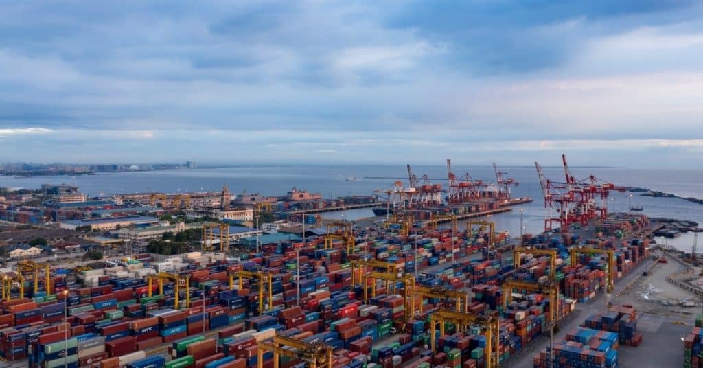
The Port of Manila is the largest port in the Philippines that also experiences the largest traffic. Like most ports in the country, it is run and managed by the Philippine Ports Authority (PPA).
The port harbours are divided into 3 main regions: the North Harbor, South Harbor, and the Manila International Container Terminal (MICT). Manila Port is classified as a natural-cum-artificial harbour covering 137.5 hectares.
Operational since the early 1100s, this port served as the primary trading harbour on Manila Bay. During the 12th century when the port was set up, it received significant trade from China, Japan, Malaysia, and India. To date, it is the premier domestic and international port in the Philippines.
The Manila North Harbor in Tondo measures 53 hectares and houses 7 berths. It includes the North Port Passenger Terminal and is the home base of 2GO, a major ferry service in the country.
The Manila South Harbor in Port Area measures 80 hectares and is operated by Asian Terminals Incorporated. It has 5 piers and the Eva Macapagal Super Terminal for passenger services.
The MICT is operated by International Container Terminal Services Inc. (ICTSI) based out of Manila and is one of the world’s busiest container terminals, ranked 38th globally in terms of TEU volume.
The modern port boasts of 22 berths and 12 piers, with average annual traffic of nearly 21,000 vessels. Manila Port has an annual footfall of 72 million passengers, a container volume of over 4.5 million TEUs, and a cargo tonnage of over 75 million tons.
The port is very well connected, with frequent bus services and a direct connection to the NLEX Harbor Link. There are planned projects to implement a rail transit line, an NLEX-CAVITEX expressway, and to link the North and South Harbors for increased efficiency.
2. Port of Cebu (Pantalan sa Sugbo)
Cebu Island, Mactan Channel, Inland Seas
UN/Locode: PH CEB
The Port of Cebu is the largest domestic port in the Philippines and one of the largest international ports in the country. It is classified as an artificial harbour and is operated and managed by the Cebu Port Authority. It primarily services the surrounding regions of Visayas and Mindanao.
The port is located in the North Reclamation Area and is divided into the domestic and international sectors. The domestic port covers 21 hectares and is further divided into 3 passenger terminals, 2 ferry terminals for the Cebu-Mactan ferries, and around 4 kilometres of berthing space for cargo ships.
The International Port covers 14 hectares and is divided into a bulk handling terminal and 0.5 kilometres of container and cargo ship berthing space.
The statistics for the port area are as follows- the annual footfall is 18 million passengers, the annual container volume is over 820,000 TEUs, and the annual cargo tonnage is nearly 31 million tons (as per 2015). The Cebu Port had 112,000 ship calls in the same year, one of the largest figures for the Philippines.
3. International Port of Batangas
Luzon Island, Batangas Bay, West Philippine Sea
UN/Locode: PH BTG
The Batangas Pier or International Port is located in Barangay Santa Clara and is the 2nd largest port in the Philippines. Covering an area of 150 hectares, it is a seaport that primarily services passenger and cargo ships. The port is managed by the PPA and customs support is provided by the Bureau of Customs (BoC). In 2015, Batangas Pier received 32,777 ship calls, handled 2.3 million tons of cargo tonnage, and had a footfall of 6.3 million passengers.
The Batangas Container Terminal is run by Asian Terminals and handles trade with Philippine industries in South Luzon. It has lower tariffs than the neighbouring Port Manila, attracting foreign investment and encouraging shipping lines to shift their operations to Batangas. It primarily competes with Subic Port as the secondary facility to ease congestion at Port Manila.
The Batangas Passenger Terminal handles tourist cruises, Ro-Ros, and ferries. It consists of 3 terminals which mainly service ships and ferries heading to the neighbouring islands for sightseeing. The main issue with the passenger terminals at Batangas is the irregular schedule, complex system of taxes and fees for tourists, and the constant threat of falling prey to scams that are commonplace within the port.
In 2016, Asian Terminals planned to revamp the port and improve its features. For this, an investment of 3.8 million pesos was announced and the plan focused on improving port connectivity, offering attractive rates and services to incoming ships, and creating a passenger-friendly environment.
There were significant issues raised about the ease of doing business at Batangas, and this was also included in the project. Road congestion was a major issue that affected the port, and work began on connecting the port to the STAR Tollway and SLEx Expressway.
There were also plans to link Batangas Pier to Manila City to hasten development. As of 2020, the work on some projects is yet to start, while others are in the planning and deliberation phase. The linking of the STAR and SLEx systems to Batangas has been completed.
4. Port of Subic
Luzon Island, Subic Bay, West Philippine Sea
UN/Locode: PH SFS
The Subic Bay Port and Freeport Zone are some of the largest commercial ports in the Philippines. It was the erstwhile base for the United States Navy after which it was converted into a bustling and vibrant harbour at Luzon.
The port is spread over Olongapo, Zambales, Bataan, and Morong. It is managed by the Subic Bay Metropolitan Authority (SBMA) which runs 25 berths. The average anchorage depth is 13.7 meters. As one of the busiest ports in the country, it is equipped to handle a maximum capacity of 600,000 TEUs.
The port has numerous investment projects, one of which is the Hanjin Heavy Industries and Construction shipyard (HHIC). At present, there are 12 piers with 3 container terminals, a grain bulk terminal (Leyte Wharf), a dedicated terminal for fertilizer shipments (Boton Wharf), and the Sattler Pier for general container cargo. A new development project envisions adding 2 berths capable of servicing Panamax and post-Panamax class vessels of 300,000 TEUs capacity.
Following the departure of the US Seventh Fleet, the base was repurposed to serve the commercial interests of the Philippines. It is connected to the Clark Air Force Base run by the government and provides revenue to the surrounding provinces in the form of exports.
5. Port of Cagayan de Oro (Dakbayan sa Cagayan de Oro)
Mindanao Island, Macajalar Bay, Inland Seas
UN/Locode: PH CGY
The Cagayan Port is located in Macabalan and is named after the Cagayan de Oro River that flows nearby. It is classified as a medium-sized artificial harbour that has an anchorage depth of 18 meters. Although it is one of the smaller ports in the Philippines, it boasts modern equipment including 4 gantry cranes.
The port was ranked 3rd in terms of first-quarter cargo tonnage behind Port Manila and MICT. It reported figures of 1.34 million tons in the April – July quarter in 2016 and witnessed an increase of 9.7% from the preceding year. The port is run and operated by the PPA.
The port also runs ferry services with the surrounding cities, and passenger influx through Port Cagayan is a major source of revenue. The main port hub includes private facilities run by General Milling and Del Monte Philippines within the premises.
The Cagayan Port includes the Mindanao International Container Port in Tagoloan and connects this harbour with top ports around the globe. The Mindanao facility is valued at $85 million and is used primarily by the PHIVIDEC Industrial Estate.
6. Port of Davao (Sasa Wharf – Daungan ng Dabaw)
Mindanao Island, Davao Gulf, Philippine Sea
UN/Locode: PH DVO
The Port of Davao is a natural-cum-artificial harbour in the Philippines run by the PPA and the Davao Port Management Office. Owned by the local government and located in Brgy Sasa, Buhangin District, the port services ships on the Celebes Sea and the Davao Gulf.
It primarily handles shipments of containerized and bulk cargo from the surrounding raw material export industries. It also has local passenger traffic transiting between various islands. It is one of the busiest international container ports in the provinces of Mindanao and Visayas.
The annual statistics of Davao Port in 2013 are as follows: the port received 25,337 ship calls, handled container volume of 544,000 TEUs, handled cargo tonnage of 9.8 million tons and received 1.6 million passengers.
The main port can be approached through the Pakiputan Strait or from Samal Island, while the Pujada Bay acts as an entrance to the Davao Oriental Port.
The harbour is mainly divided into the government and private piers, and pilotage services are provided to incoming vessels. The Davao Port is divided into 2 government facilities and 9 private sections.
The Sasa International Seaport is the main port hub and is run by the government through the ICTSI. It runs an international container terminal and is the busiest and largest section of the port. Another important and busy section of the port is the Stevedorage Services Corporation Pier that services cargo ships of all types. The rest of the port is divided into the Sta.
Ana Pier for domestic vessels (which is the 2nd government-owned subport), the Mati Davao Oriental Wharf for timber and general cargo, the Pacific International Terminal Pier for banana and fruit exports, the Legaspi Oil Company Pier for coconut product exports, the Universal Robina Pier for grain imports, the Davao Union Cement Pier for ore exports, the Piso Point Port for mineral exports, and the Tefasco Port for asphalt and industrial good handling.
7. Port of Iloilo (Pantalan ng Iloilo)
Panay Island, Iloilo Strait, Inland Seas
UN/Locode: PH ILO
The Iloilo Port is located on the Panay Gulf within the Visayas province. It is regarded to be the safest port in the country since Guimaras Island shields the harbor from a majority of storms and harsh wave conditions.
It is classified as a natural harbour and has been operational since 1855. Trade increased significantly with the opening of the Suez Canal in 1869 and Europe is a major trading partner with the Iloilo Port.
The Port offers bunkering facilities provided by Pilipinas Shell, Caltex Philipines Inc., Petrophil Corp, and Petroleum Corp. As a major port in Western Visayas, the Commercial Port Complex is built on reclaimed land and is outfitted with modern equipment.
The port is mainly divided into the International Port in Loboc, the Domestic Port in City Proper, the Lapuz Wharf in Lapuz, the Ortiz Wharf in City Proper, and the Guimaras-Iloilo Ferry Terminal (GIFT) in Parola.
There are regular ferry services offered by the Lorenzo Shipping Corp and 2GO. The ferries connect Iloilo with the surrounding regions, while the ro-ro services connect it to Guimaras and Negros (the name of a nearby island).
The Port is ranked 3rd in terms of overall ship calls and has an annual footfall of 2.4 million passengers. The annual cargo tonnage is 0.5 million tons. The port complex includes 400 meters of berthing space and an anchorage depth of 10.5 meters.
8. Port of General Santos (Makar Wharf)
Mindanao Island, Sarangani Bay, Celebes Sea
UN/Locode: PH GES
The General Santos Port, known regionally as the Makar Wharf, is a medium-sized harbour facility in the Philippines, run and operated by the PPA. Located in Barangay Labangal, it is the primary international port in the city. The port consists of a 740-meter-long dock that can service 9 ships simultaneously.
With modern cranes and storage facilities, it is an export and import hub for many shipping lines. There are also several ferry services run from this port to the nearby islands and provinces. There are also international ferries, with the main service between the Philippines and Indonesia.
The Makar Wharf also runs a Fish Port nearby, which services reefer containers at the main port. The primary purpose of the Fish Port is as a retailer of high-grade tuna used for sashimi and a consolidation port for international export of fish caught by the local fishing industry. The Fish Port is run out of Barangay Tambler and is one of the most modern facilities in the country, with state-of-the-art facilities to process fish.
9. Port of Zamboanga
Mindanao Island, Basilan Strait, Celebes Sea
UN/Locode: PH ZAM
The Port of Zamboanga is a major port in the Philippines and is run by the PPA and the Port Management Authority – Zamboanga (PMO-Z or ZFA).
It is an artificial harbour covering 15.6 hectares and operates 19 wharves. The Zamboanga Free Port is also run by the ZFA. The port has received many laurels including the 2nd rank in the “Super-Efficient Ports in Asia” study. The primary export from Zamboanga is sardine which is shipped to the US, Europe, the Middle East, and over Eastern Asia.
To supplement the shipments, the port receives 25 different shipping lines within the 4 sub-ports. There are 19 docks of which 12 are run by private entities.
The size of each dock varies and the largest one can berth 20 vessels. Besides the cargo exports, passengers account for significant revenue to the port with the annual footfall exceeding 5.5 million in recent years.
The port handled 8.4 million tons of cargo tonnage and 2.7 million TEUs of container volume in 2012. It had over 14,000 ship calls in the same year with a majority being domestic ferries and passenger crafts.
10. Port of Lucena
Luzon Island, Tayabas Bay, Inland Seas
UN/Locode: PH LUE
The Port of Lucena is a major fishing and commercial port located on the Bay of Tayabas. It is known as the “melting pot” of South Luzon and plays a major role in revenue for the locals.
The port is operated under the PPA and is located in Barangay Talao-Talao. Built as a natural-cum-artificial harbour, it covers roughly 5,000 square meters with most of the area set aside for commercial activities.
The Dalahacian Fishing Port is located a short distance from Port Lucena and is another major fishing hub in Luzon. Both are located close to the ports of Manila and Batangas and handle the overflow of vessels from these larger ports.
While Dalahacian predominantly handles fish exports and local retail, Lucena doubles up as a cargo and fishing port. Both ports are inter-connected but lack a robust transportation system with major metro cities.
The port also has numerous ferries used by the locals to reach the neighbouring islands.
Source: Marine Insight


